You: want to plan an orienteering event
You: are short of specific ideas
You: will get new ideas for your orienteering event
The article, featuring lots of images of orienteering maps, is attached as a PDF file.
I’m sitting at my desk. In front of me lie the quarterly planner and a blank sheet of paper. Deep down, I’m (still) harbouring the hope of planning an orienteering event that’s a bit different for a change. Thoughts are racing through my head: “Weren’t the Young Scouts so frustrated at the last orienteering event because they could only find so few control points?” – “Didn’t we have to go and look for one group because nobody could make head nor tail of the map?” – “And wasn’t there Peter, who simply ran off from his group and wanted to do everything himself?” Oh, if only we’d just decided during the quarterly planning meeting exactly what this orienteering event should look like! That would have saved me a lot of brainwork.
To help ensure your next orienteering event really is a bit different, here are a few ideas. Give them a go – it’s well worth it.
How do I plan an orienteering afternoon?
It is clear that we need to introduce the Young Scouts to the topic of ‘orienteering’ gradually. The ‘Input’ article ‘NORDA – an introduction to orienteering’ (Input 3/00 – JS) provides a sample lesson showing how young scouts can be given guidance in orienteering.
Once the young scout is familiar with the key elements of orienteering, we can start thinking about specific orienteering ideas.
Types of training:
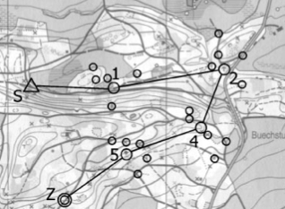
Snowball Orienteering
This group orienteering event offers a great opportunity for youth groups with runners of varying abilities. The group runs the sections to the central control points together. There, they split up and each runner seeks out a control point according to their skills and ability. It is also possible for each runner to choose which sub-control points to visit, so that they can then compare the different routes.
Blame Game Orienteering
Participants set off in groups of three to five runners, each equipped with a single map. The leader changes every three or four minutes. Anyone who does not know where the running group is will be saddled with a ‘Schwarzer Peter’. If the leader does not know the location themselves, they are immediately awarded two penalty points.
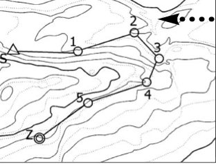
Contour Map Orienteering
A contour map is a special type of reduced map. Reduced maps are produced by omitting one or more colours from the map. In the case of a contour line map, this is a map without the colours green, yellow and black. Other colour combinations can also be produced. An orienteering course using reduced-colour maps helps to develop specific map-reading skills. Contour line orienteering is particularly suitable for training spatial awareness. Particular care should be taken in contour line orienteering to ensure that the runner can follow terrain features (e.g. the line of fall, gullies, horizontal paths). Control points are normally situated on hilltops, in hollows, in gullies or on ridges.
Orienteering Golf
Runners are divided into teams of two and given a map. They visit the control points in turn, with each glance at the map – supervised by their running partner – counting as a ‘golf stroke’. Anyone who only needs to consult the map once between two control points scores a ‘hole in one’. To ensure fairness, the scoring is divided into two groups based on runners with even-numbered and odd-numbered control points.
Memory Orienteering
This orienteering event for professionals relies heavily on spatial awareness. At the start and at each control point, the runner is given a small section of a map which they must memorise. The search for the next control point is then carried out entirely from memory. It is important that the runner does not simply memorise the route as a sequence of ‘right-left-left-straight-right-’, but instead visualises the terrain both spatially and in terms of its features.
Simple course layouts
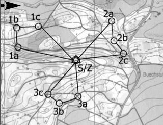
Star-style orienteering
In the best-known of all orienteering variants, the control points are always approached from the same start and finish point. Only the control points and the centre are marked on the map. The runner determines the route themselves. This is particularly popular with beginners, as instructors on hand can provide assistance if they are unsure. For the absolute beginners, routes can also be marked with flags so that runners can compare the map with the terrain.
Butterfly Orienteering
Similar to star-shaped orienteering, the control points are arranged around a centre, although here two to four control points are linked together to form a short route.
Text Orienteering
With a descriptive text instead of a map, the runner is forced to interpret specific objects and identify them in the terrain. Text orienteering is therefore particularly well suited to beginners in varied terrain. This form of orienteering can also be developed with teenagers and then carried out with young scouts.
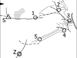
Sketch orienteering
In a sketch orienteering event, the runner is given a sketch map. This format has the advantage that features specific to that day (e.g. a fallen tree, a gap in a fence, etc.) can be incorporated into the course. Insignificant details are omitted. This makes it possible to keep the running route very narrow. Naturally, this format requires quite a lot of preparation.
Butterfly Orienteering / Crocodile Orienteering
Orienteering for Advanced Participants
Compass (Star) Orienteering
Compass orienteering can be organised in various ways. In its simplest form, runners are given only the bearing and the distance. After reaching a control point, the runner returns to the finish and sets off for the next control point. To ensure the runners work accurately, it is a good idea to plot the control point locations on a map. This enhances the learning experience and also allows participants to practise map reading.
VFF Orienteering (Many false or missing control points)
To practise working accurately with a map, various incorrect or even missing control points can be placed on an orienteering course. Incorrect control points are, for example, positioned on a neighbouring feature or on the wrong side of the path. The runner only scores a point at the correct control point, which they have reliably located using precise orientation based on terrain features (and not by the control flag). They mark missing control points accordingly on the map.
Score Orienteering
In a score orienteering event, it is not the course but the time limit that is set. Within this time, runners must collect as many points as possible. Points are awarded at the control points according to their difficulty (distance, density of controls, altitude, etc.). Points are deducted for each time limit exceeded. This format is suitable when time is limited and the number of participants varies greatly. It places particular emphasis on the participant’s route-planning skills.
Scored Orienteering

Further resources
You can obtain an overview of the available orienteering maps, including where to order them, by sending a stamped and addressed return envelope to (you’ll also find plenty of other materials here, such as orienteering ribbons, control points and training materials):
Orienteering Equipment Centre, Marianne Graf, Altlandenbergstrasse 40, 8494 Bauma
The ‘Leader’s Handbook on Orienteering’ is a useful resource for organising youth club afternoons and camps featuring various orienteering activities. You can obtain it from the ESSM equipment centre in Magglingen.
Source:
Content + image:
Forum Kind 3/02. Practical ideas for various orienteering variations, suitable for all ages and ability levels, pages 27–30
Copyrightwww.forum-kind.ch
Author:
Lori Keller, Youth Group Secretary at the BESJ